For the preservation, protection, and maintenance of Lake St. Catherine |
 |
A Lake Watershed Action Plan For Lake St. Catherine
THE LAKE ST. CATHERINE WATERSHED ACTION PLAN
The Lake St. Catherine Watershed Action Plan was completed on June 30th, 2025.
You can view the Plan and supporting documents by clicking here.
A presentation discussing the Plan can be viewed below:
INTRODUCTION
After many months of work over the winter, the Lake St. Catherine Association was overjoyed to learn that our proposal to the Lake Champlain Basin Program (LCBP) to create a Watershed Action Plan was accepted!
We first told you about Watershed Action Plans, and our efforts to earn a grant to fund the creation of one for Lake St. Catherine, in our Spring 2021 newsletter. At that time, all the grant application work had been completed, and we were awaiting word on our proposal. Then, just days after the publication of the Spring 2021 newsletter, we received the news that we had earned the grant - our largest grant award to date! So, we’d now like to take some time to explain just how important this effort will be for Lake St. Catherine.
WHAT IS THE PURPOSE OF A LAKE WATERSHED ACTION PLAN (LWAP)?
The Vermont Department of Environmental Conservation (DEC) recently released a document entitled “Technical Guidelines for Conducting a LWAP: Issues and Objectives, Methods and Assessments, Process, and Reporting”, which we will be referencing throughout this article. Excerpts from this document will be indented and begin with [DEC]. The Vermont DEC describes the purpose of LWAPs as:
[DEC] A Lake and Watershed Action Plan (LWAP) is designed to identify and communicate the problems and fixes within a lake watershed to best protect water quality, wildlife habitat, and the lake’s ecosystem health. These plans answer the questions 'what issues threaten the health of our lake the most?' and 'what can we do about them?'
WHAT IS A LAKE WATERSHED ACTION PLAN?
[DEC] A LWAP is an assessment to identify the greatest threats to the lake ecosystem, including impacts on water quality and wildlife habitat from stormwater runoff and from altered, cleared, or converted shorelands. LWAPs are designed to answer specific concerns about each lake, for example, what land uses within the watershed cause the greatest stress to a lake ecosystem. Each lake has different land use patterns and understanding exactly which ones are causing degradation to the lake will help guide restoration and protection efforts. The LWAP assesses and compares the varying land uses and provides a ranking of the greatest threats to the lake along with recommendations for fixing the problems. A LWAP combines an assessment of a lake’s shoreland, tributaries, and hydrologically connected roads and leads to an individual planning guide that prioritizes restoration and protection actions for that lake. A LWAP can also help identify cumulative impacts on a lake ecosystem, thereby helping lake stakeholders “see the bigger picture” and identify situations where the combination of individual stressors may be leading to declines in lake health.
A LWAP is an investigation into potential threats to the lake’s ecosystem health, and the process should be participatory with the lake association or similar local organizations, lake users, shoreland owners, the Town, and other stakeholders or interested groups and people. A LWAP Final Report will also include a list of prioritized problems and solutions and provide a table of projects. This prioritized list of projects and strategies is intended to address the sources of pollution and habitat degradation identified in the assessment, with some of these projects benefitting from preliminary ecological and conceptual design work as part of the LWAP development process. The prioritized list of projects can feed into the DEC Watershed Projects Database and be considered for funding under the Clean Water Initiative Program (CWIP) and other sources.
WHY IS A LWAP SO IMPORTANT FOR LAKE ST. CATHERINE?
After many years of successfully managing individual lake programs which include: in-lake invasive species control (Milfoil Control Program), invasive species prevention (Greeter Program), and stormwater management (Lake Wise Program), the LSCA is now poised to integrate these programs into a broader watershed plan with a focus on the prevention of pollutant loads (phosphorus, nitrogen, sediments) that enter into the Lake from sources outside the waterbody. The LSCA plans to use the success of these building blocks to expand its work in the watershed and focus on prevention for the future as part of a comprehensive long-term plan. The resulting plan will leverage current LSCA investments in water quality and pollution prevention, be driven by accepted best management practices, elevate under-assessed areas and gaps, and will identify issues, opportunities, and projects to guide locally-led water quality implementation work in the Lake St. Catherine watershed.
 WHAT IS THE LAKE ST. CATHERINE WATERSHED?
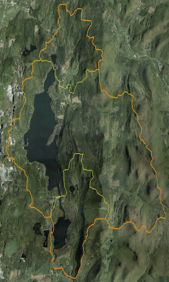
A watershed is defined as an area of land area that drains to a common body of water, from streams and runoff from all the land uses. The orange outline on the map to the right shows the whole of the LSC watershed. The yellow outlines running east-west below Lily Pond and above Little Lake indicate their individual watershed boundaries. You can see how the watershed extends well past the area of the Lake.
WHAT IS THE GOAL OF THE LAKE ST. CATHERINE LWAP?
[DEC] The goal of a LWAP is to evaluate water quality conditions and related stressors in a lake and its watershed to identify the greatest threats to the lake ecosystem, including sources of increased stormwater runoff and associated sediment and nutrients as well as other important stressors such as invasive species, habitat loss, erosion, and other threats that may lead to loss or degradation of defined uses under the Vermont Water Quality Standards.
Specifically for Lake St. Catherine, the findings from the creation of the LWAP will guide our long-term efforts to increase water quality by reducing erosion, and by reducing the amount of phosphorus, nitrogen, sediments, and other pollutants from entering the Lake.
WHAT WILL THE CREATION OF THE LAKE ST. CATHERINE LWAP EXPLORE?
The LSCA will assemble a project team of lake experts, including: the Poultney Mettowee Natural Resource Conservation District (PMNRCD), Castleton University, lake scientists (limnologists), consulting with our LSCA membership & the lake community to create a detailed assessment of the watershed. Three core field assessment components to be evaluated in the watershed are the shorelands, the roadways, and the tributaries (streams).
Although the LSCA has collected almost 40 years of data about LSC’s phosphorus (nutrient) concentration, chlorophyll-a (algae and cyanobacteria) concentration, and Secchi depth (water clarity) as part of Vermont’s Lay Monitoring Program, the team will work to greatly expand the testing, measuring, and monitoring of water parameters. The team will also evaluate and consider the characteristics and special needs of unique areas of the Lake like in our bays and channels - and everything in-between, from the Lily Pond, through the Big Lake & Little Lake, to Lake's End.
WHAT CAN YOU DO TO HELP?
This effort will only be successful if we have the support of the lake community. To earn funding for the projects that will be identified by the LWAP, we need to demonstrate to the State and to other grant funding entities that we are worthy of earning their funding by showing we are invested in the future of Lake St. Catherine.
How can we do this?
- First and foremost, become a member of the LSCA to show your support. Our membership participation is approximately 50% of property owners around the Lake - and these membership contributions accounted for 44% of our budget in 2021.
- Sign up for the Lake Wise Program so that you can learn how (and get assistance) to make your property and shoreline Lake friendly.
- Participate in upcoming LWAP meetings (to be scheduled), and complete the Lake Property Owner survey when released.
- Be an advocate for the LSCA and the Lake. Speak to your neighbors about becoming a member and participating in Lake Wise, be on the lookout for issues or conditions that may be impacting water quality, and continue to learn about best practices for your shoreland property.
HOW WILL WE MEASURE OUR SUCCESS?
After a thorough inventory of our watershed is completed and evaluated by our project team, projects will be designed to address the issues identified. We will then be in a position to seek funding from the CWIP and other sources for these initiatives. As these projects are implemented, we will be able to evaluate their impact by collecting, comparing, and interpreting the water quality data as part of our measuring and testing program, ie. are phosphorus and chlorophyll-a levels decreasing, is water clarity increasing?
In summary, we are proud to have earned this grant, and we look forward to putting in the good, hard work it will take over the next 10 years… For the preservation, protection and maintenance of our beautiful Lake St. Catherine - we hope you will join us. Thank you.
